By Sarah Hansen
Yujie Wang, Associate Research Scientist at the NASA Goddard Space Flight Center in Greenbelt, MD and part of the Joint Center for Earth Systems Technology (JCET) between UMBC and Goddard, recently received the NASA Peer Award for Outstanding Scientific Support. The award recognized his contributions to the development of a new algorithm that detects light reflected from Earth’s surface. Surface reflectance data are used to study Earth’s total energy budget, enhance climate models, reveal natural vegetation dynamics, and detect human-generated land surface change. The algorithm is known as MAIAC (Multi-Angle Implementation of Atmospheric Correction).
Models have existed to derive surface reflectance from satellite measurements for decades. What makes MAIAC groundbreaking is that it significantly improves accuracy by better detecting clouds and removing atmospheric effects, in particular scattering and absorption of light caused by tiny pollutant particles called aerosols.
“MAIAC is the only algorithm that provides one kilometer resolution aerosol data, as compared to three to approximately 20 kilometer data from standard algorithms,” said Alexei Lyapustin, Physical Research Scientist at Goddard and Wang’s nominator and colleague. The extra resolution is especially valuable in regions with complex topography or in urban areas where air quality can change significantly over small distances.

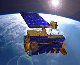
An image of Terra, one of the satellites that carries the MAIAC algorithm
(http://en.wikipedia.org/wiki/Terra_%28satellite%29)
The aerosol properties MAIAC provides are turning out to be extremely valuable. “At the beginning we were just focusing on surface reflectance, but lately the aerosol product has been gaining popularity,” said Wang. “A large and diverse air quality community uses this information to assess aerosol impact on human health.”
Another huge advantage to the new system, and remote sensing in general, is its scope. The algorithm is implemented in the MODIS instrument (MODerate resolution Imaging Spectroradiometer) on two satellites, Terra and Aqua. Every two days, together the satellites cover the entire Earth. “If you do ground measurements that takes a lot time, a lot of money, a lot of people, and you cannot do full coverage. But a satellite can easily get global coverage,” explains Wang.
The MAIAC algorithm takes advantage of high-powered computers to incorporate time-series and spatial data into the analysis. Because of computing limitations, previous methods examined one image at a time, pixel by pixel. Using those methods, the problem is not well defined because for each measurement there are two variables: actual surface reflectance and the amount of aerosols. So out of necessity, most models make simplifications and assumptions. But with MAIAC, “We keep 10 to 16 days of images in the memory,” said Lyapustin, “and we have enough information to solve the problem without major assumptions.”

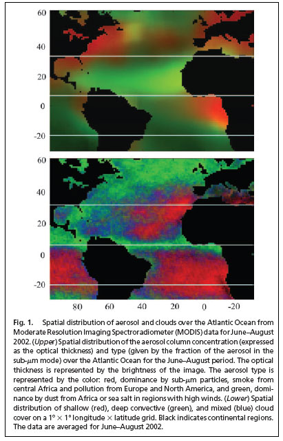
An example of an aerosol image provided by MODIS
(http://modis-atmos.gsfc.nasa.gov/MOD04_L2/sample.html)
The fully-developed algorithm has been a long time coming. Wang started thinking about this when he first arrived at JCET in 2002. “At the beginning it was just an idea—that we could use more time-dependent and spatial information to do this,” he said. After running some preliminary tests using other instruments, full-on algorithm development started in 2004. Wang has been at it since then.
“He more than deserves this award,” said Lyapustin. “Besides supporting scientific development of MAIAC, Yujie’s major contribution came from a programming perspective,” he said. “He has excellent programming skills and developed a very sophisticated system. It allows us to work with the time series of data and use both individual pixel information and spatial information about a pixel’s surroundings.” Wang’s expertise allows Lyapustin and others to dive into the data collected from the satellites. Thanks to Wang, they can easily manipulate time and space dimensions to look for patterns.
The Peer Award comes with a small monetary prize, which Lyapustin sees as “encouragement to continue great work,” but he points out, “Yujie has no need of encouragement.”
Besides conducting his own research, Wang plays the important role of communicating with other researchers and providing them the MAIAC data they request to explore fields like air quality and climate change. “Now that more and more people are using our products, they are getting some really exciting results from the data—I kind of provided them with those new data, and they are pretty happy about that,” he said.
Yujie Wang, Associate Research Scientist at the NASA Goddard Space Flight Center in Greenbelt, MD and part of the Joint Center for Earth Systems Technology (JCET) between UMBC and Goddard, recently received the NASA Peer Award for Outstanding Scientific Support. The award recognized his contributions to the development of a new algorithm that detects light reflected from Earth’s surface. Surface reflectance data are used to study Earth’s total energy budget, enhance climate models, reveal natural vegetation dynamics, and detect human-generated land surface change. The algorithm is known as MAIAC (Multi-Angle Implementation of Atmospheric Correction).
Models have existed to derive surface reflectance from satellite measurements for decades. What makes MAIAC groundbreaking is that it significantly improves accuracy by better detecting clouds and removing atmospheric effects, in particular scattering and absorption of light caused by tiny pollutant particles called aerosols.
“MAIAC is the only algorithm that provides one kilometer resolution aerosol data, as compared to three to approximately 20 kilometer data from standard algorithms,” said Alexei Lyapustin, Physical Research Scientist at Goddard and Wang’s nominator and colleague. The extra resolution is especially valuable in regions with complex topography or in urban areas where air quality can change significantly over small distances.
An image of Terra, one of the satellites that carries the MAIAC algorithm
(http://en.wikipedia.org/wiki/Terra_%28satellite%29)
The aerosol properties MAIAC provides are turning out to be extremely valuable. “At the beginning we were just focusing on surface reflectance, but lately the aerosol product has been gaining popularity,” said Wang. “A large and diverse air quality community uses this information to assess aerosol impact on human health.”
Another huge advantage to the new system, and remote sensing in general, is its scope. The algorithm is implemented in the MODIS instrument (MODerate resolution Imaging Spectroradiometer) on two satellites, Terra and Aqua. Every two days, together the satellites cover the entire Earth. “If you do ground measurements that takes a lot time, a lot of money, a lot of people, and you cannot do full coverage. But a satellite can easily get global coverage,” explains Wang.
The MAIAC algorithm takes advantage of high-powered computers to incorporate time-series and spatial data into the analysis. Because of computing limitations, previous methods examined one image at a time, pixel by pixel. Using those methods, the problem is not well defined because for each measurement there are two variables: actual surface reflectance and the amount of aerosols. So out of necessity, most models make simplifications and assumptions. But with MAIAC, “We keep 10 to 16 days of images in the memory,” said Lyapustin, “and we have enough information to solve the problem without major assumptions.”
An example of an aerosol image provided by MODIS
(http://modis-atmos.gsfc.nasa.gov/MOD04_L2/sample.html)
The fully-developed algorithm has been a long time coming. Wang started thinking about this when he first arrived at JCET in 2002. “At the beginning it was just an idea—that we could use more time-dependent and spatial information to do this,” he said. After running some preliminary tests using other instruments, full-on algorithm development started in 2004. Wang has been at it since then.
“He more than deserves this award,” said Lyapustin. “Besides supporting scientific development of MAIAC, Yujie’s major contribution came from a programming perspective,” he said. “He has excellent programming skills and developed a very sophisticated system. It allows us to work with the time series of data and use both individual pixel information and spatial information about a pixel’s surroundings.” Wang’s expertise allows Lyapustin and others to dive into the data collected from the satellites. Thanks to Wang, they can easily manipulate time and space dimensions to look for patterns.
The Peer Award comes with a small monetary prize, which Lyapustin sees as “encouragement to continue great work,” but he points out, “Yujie has no need of encouragement.”
Besides conducting his own research, Wang plays the important role of communicating with other researchers and providing them the MAIAC data they request to explore fields like air quality and climate change. “Now that more and more people are using our products, they are getting some really exciting results from the data—I kind of provided them with those new data, and they are pretty happy about that,” he said.